


Courtesy of A Vision of Britain Through Time
A Vision of Britain Through Time for today’s Follow Friday brings together historical surveys of Britain to create a record of how the country and its localities have changed.
A Vision of Britain Through Time was created by Humphrey Southall and the Great Britain Historical GIS Project at the Department of Geography of the University of Portsmouth. More information about the project, and about historical applications of GIS technology, is available at their Web site at www.gbhgis.org.
I use this site to confirm how place names in my Scottish research have changed over time. Here are the results for Kirkmichael in Moray and Banffshire:
In 1887, John Bartholomew’s Gazetteer of the British Isles described Kirkmichael like this:
Kirkmichael, par., in S. of Banffshire, on river Avon, 75,759 ac., pop. 1073; the church is 4 miles NW. of Tomintoul.
A Vision of Britain through Time includes a large library of local statistics for administrative units. For the best overall sense of how the area containing Kirkmichael has changed, please see our redistricted information for the modern district of Moray. More detailed statistical data are available under Units and statistics, which include both administrative units covering Kirkmichael and units named after it.
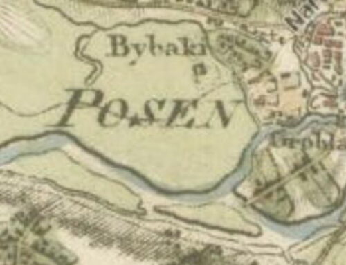
The site also provides maps in overlays that you can change by time. (see above right)
And I have to love any site that helps you cite it effectively, which they do very precisely with a URL specific to the search.
How to reference this page:
GB Historical GIS / University of Portsmouth, History of Kirkmichael, in Moray and Banffshire | Map and description, A Vision of Britain through Time.
URL: http://www.visionofbritain.org.uk/place/16581
Date accessed: 04th August 2013

Leave a Reply