

 The ASPRS Aerial Data Catalog is a free aerial photography resource for genealogists to use in their research.
Provided by the American Society of Photogrammetry and Remote Sensing (ASPRS), this is a useful tool for locating aerial photography for both U.S. and international geographic areas of the past and the present. ASPRS bills this database as “the Source for Finding Aerial Collections”.
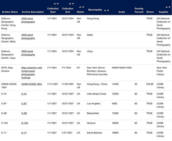
The ASPRS Aerial Data Catalog aggregates aerial photography from private companies, universities, states, non-governmental organizations, and federal sources. The catalog contains metadata allowing users to determine if coverage exists over an area of interest. The acquisition date, film type, sensor type, and scale are also provided along with the repository contact information. Click here for more information.
Once you have located a set of records, you can narrow a search by applying a filter once, or multiple times, to refine your search. If you need assistance, please check the Help page for more tips.
Here are some of the latest uploads to this site, including aerial photos from the 1920s and 1930s:
This free aerial photography resource for genealogists would be particularly valuable to pinpoint structures on land as they may have existed in earlier decades. What other uses could this have for your family history research?
Another helpful resource for U.S. researchers is the Board of Geographic Names, to help you follow changes to names of your ancestors’ locations.


I tried to bring up aerial photo of Ventura, Ca. 1/1/1927 (listed as available Archive # C-104…and couldn’t find a way to do this. Reply with further instructions, please.
Sibyl Baker [email protected]
Hi Sibyl, I don’t run this site, I just linked to it. Try the Help page for info on using the site. If you still have trouble, contact the website manager using Contact Us page.