
Today’s post is about OpenStreetMap and genealogy. I believe the next big advances in genealogy (and historiography) are coming from the growing ability to add historical data to mapping applications.
I’ve written about HistoryPin and WhatWasThere, both of which combine mapping and photographs. Another great project in this area is OpenStreetMap, a free, editable map of the whole world, which is of interest to genealogists for both input and research.

OpenStreetMap is open source, which means anyone can contribute to and edit the data. The OpenStreetMap license allows free access to the full map dataset, which can be downloaded in full. And because it’s open source, users can view changes and additions made over time to the database that underpins the map.
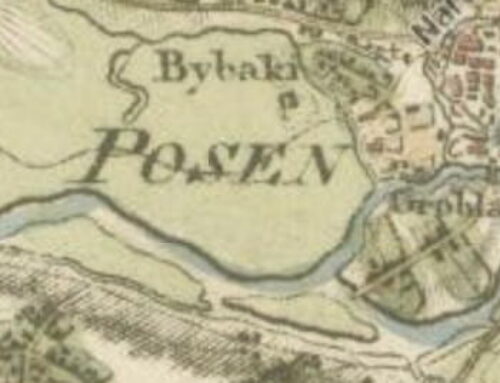
Also included in search results on OpenStreetMap are other bits of geographical information dear to genealogists, like variant names, counties or other geographical hierarchy, and links to Wikipedia and GeoNames. The example above uses one of my former Prussian and now Polish ancestral villages, Rawitsch.
The latest efforts for OpenStreetMap are focussed on adding historical information to the map data set. There are still technological challenges to resolve, include standardizing variable historical time formats, incorporating and annotating sources, and figuring out how to track the provenance of historical data.
Jeff Mayer, who is working on the project, writes:
[OpenStreetMap] enables people to extend others’ efforts and immediately share what they’ve done, which is a fairly unique and powerful capability. In addition, a current map of the world already contains much information about its history. One of the goals of the Historical OSM project is to leverage OSM’s great authoring, database, and rendering tools to make it easier to combine projects and to collaborate. Hopefully, academics and educators [and genealogists!] will be able to spend more time authoring and creating and less time worrying about setting up infrastructure.What’s the difference between OpenStreetMap and Google Maps or Google Map Maker? Google uses proprietary data for their maps, which means Google has the exclusive legal copyright to the map data and can limit user access and functionality. You can compare Web-based mapping services here.
Want to know more?
- “The ‘Spherical Mercator’ of Time: Incorporating History in Digital Maps,” in the Signal blog from the Library of Congress.
- OpenStreetMap Historic listserv and wiki.
- OpenStreetMap’s annual international conference, State of the Map, is the global gathering for everyone contributes to and/or uses OpenStreetMap. In 2007, there were 10,000 registered users and 50 million GPS data points; by 2013, there were 1.1 million registered users and 3.2 billion GPS data points.
Darn, another fabulous enhancement to learn about. The geographical dimension over time is a critical element that will make possible intelligent searches, rather than endless name grabbing.
Thx, SK. I’m impressed with the work you’ve all done.
For readers of this blog interested in Irish genealogy the Irish chapter of OpenStreetMap have a very active project to map all the townlands (see http://en.wikipedia.org/wiki/Townland) of Ireland. A list of current progress is here: http://www.celtic-knot-creator.com/townland/, and a more detailed explanation of the how and why here: http://www.irelandxo.com/node/10127.
Also the OpenStreetMap Historical initiative is closely linked with a Wikimedia Commons initiative working with old maps : http://wikimaps.wikimedia.fi/.